Map Illustration
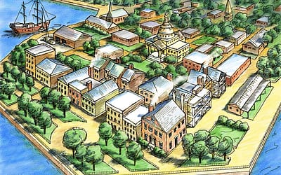
Aerial Map of Charleston, S.C.
This aerial perspective map of Charleston, S.C. was done for educational textbook use. It demonstrates how the town looked and developed earlier in its history. The art was done in Corel (Fractal) Painter software, with a line art layer, and a watercolor art layer...
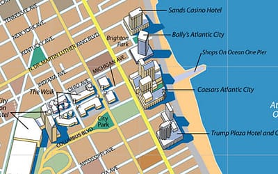
Atlantic City, New Jersey, Map Illustration
This preliminary city map was illustrated in Adobe Illustrator by Randal Birkey and intended for use to sell advertising to the businesses in that city. It featured all the major casinos, and shopping spots as a means to attract additional businesses to advertise on...

Ameritech Mobile Paging Services Coverage Map
Ameritech Mobile and Ameritech Paging were major wireless carriers headquartered in Chicago during the 1980's as the cellular-mobile-paging market was in its infancy. These firms were an outgrowth and result of the old Bell Telco system before deregulation. Randal did...

Aerial Perspective of a Mission
Randal did this aerial perspective of a mission for an educational textbook through Design Associates for Scot Foresman, the publisher. The idea was to illustrate a typical mission as it was usually organized and built. The book designers added labels and captions to...

Base Maps
OBJECTIVE To create a number of Chicago area base maps in Adobe Illustrator (Postscript - vector) format, to enable a wide range of customization and personalization by RANDAL BIRKEY clients. SOLUTION Randal Birkey has created a number of such base maps that can be...

American Invsco – Delaware Place – Chicago, Illinois
OBJECTIVE A leading US condominium developer, American Invsco, required a marketing map and new condo building illustration of a new development in Chicago called Delaware Place. SOLUTION Randal Birkey created a street level detail map of the neighborhood around the...

US Swine Flu Map Animation
The team at Headstand Media produced a US Swine Flu Map Animation which was online at http://www.swine-flu-map-animation.com This tool was used on a daily basis to track the spread of the disease over time from state to state in a visual and animated manner. It...

Corporate Site Plan Illustration
Randal Birkey created this site plan of what eventually became an insurance office campus in the northern suburbs of Chicago in the 1980’s. The developer was Homart, and the project called Riverwoods. The original art was done with pen and ink line work, and color...

Rand McNally CityFlash Maps
OBJECTIVE As the recognized premier global map company, Rand McNally was exploring the possible transition from traditional cartography techniques to digital map production in the late 1980s. A new map product line called "CityFlash" maps was their first test case map...

Falling Water Master Site Plan
This site plan map was done for Lipman-Hearne, a Chicago design firm that was designing print materials for a residential housing development by Pacific-Sakata, in the 1980s. The development was called Falling Water, similar to the name of a famous Frank Lloyd Wright...

Chicago Area Map Illustrations
I've done so many map illustrations in my career, I've lost count. Many of them are of the Chicago area. The one on the left I did in 1995 of the Chicago area, featuring all the main Interstate highways, Lake Michigan, the outline of Chicago and border counties. It...